The Aran valley is a fascinating place for many reasons – not least because it is in Spain/Cataluña, but on the French side of the Pyrenees. Normally when you pass through a long road tunnel to the northern side of the mountain chain you head into France, but not in this instance. The Vielha tunnel – which measures some 5.2 kilometres – takes the motorist into the Aran, which is still part of greater Iberia.
As befitting such a place, it has several names – the Val d’Aran (the official name); the Vall d’Aran (Catalan); and the Valle de Arán (Spanish). This is because it has no less than three languages in operation. The official name of the valley is in the local tongue ‘Aranés’ – which in turn is a dialect of ‘Gascón’, which is a dialect of the Occitan language still spoken in some areas of southern France. Confused? You will be. The other two official languages are Catalan and Spanish.
The valley has its own ‘government’ in the town of Vielha, which is called the ‘Consejo General de Arán’ and is similar to provincial governments around Spain, but only looks after a population of around 10,000 people. So, as you can see, from a historical and cultural point of view, it is a place of enormous interest – certainly unique – although similar in some regards to other mountain ‘kingdoms’ in Europe.
The Val d’Aran is on the northern edge of the Cataluña lake district, although there is no such official name. There are many hundreds of glacial lakes dotted all over the Pyrenees but nowhere else has such a great concentration of them. If walking in the Pyrenees is normally extremely pleasurable, then it takes on an extra dimension when glacial lakes form part of the picture.
Approaching the area from the north gives a different perspective and experience. The northern slopes see less sunlight and are likely to be iced up in winter and parts of the spring and autumn, but offer relief from heat in the summer. Another point to consider is that it is a short car journey to the ideal start points for the walks – or at least an extra 10km of walking each day without a vehicle. The other option is to use the GR-211.4 and GR-211.5 to hike up to higher paths and create a multi-day trek using the network of mountain hostels (refugios/refugis) in the area for overnight stays.
Once again it is the GR-11 trans-Pyrenean footpath and its off-shoots which provide the basis for the best walks. Sections of the routes described here also form part of the walk from the west, outlined in the previous post.
A map of the area which shows all the different possibilities on offer is the Editorial Alpina’s 1:40,000 scale sheet entitled Val d’Aran. A good peruse of the map will show the possibilities for a walking holiday, using the network of mountain refuges (refugios) situated along the GR-11 trail. When you buy your map to check out the routes, you will notice that glacial lakes here are referred to in two different ways. Outside of the influence of the valley they are ‘estany’, which is Catalan – but in ‘Aranés’ they are ‘estanh’. Not far away – a day’s hike to the west on the GR-11 trans-Pyrenean footpath – the walker enters the Aragón region, where glacial lakes are called ‘ibón’. This isn’t Spanish either, it’s the ancient ‘Aragonés’ language. But that’s another story.
Interactive maps can be found online at the website of the Catalan walkers’ federation, Federació d’Entitats Excursionistes de Catalunya (FEEC). On accessing their site at www.feec.cat scroll down to ‘senders’ (footpaths), where they give the stages and maps of many the GRs in their region, including the GR-11. The interactive maps also allows the user to check out the GR-11.18 which is mentioned below.
There is a huge amount of accommodation available in the Val d’Aran. The most luxurious is in the ‘capital’ of Vielha. However, there are many other options in the picturesque outlying villages such as Tredos and Arties – as well as campsites. Options can be viewed via booking.com
The campsite at Arties, named Camping Arties Era Yerla, which has chalets as well as pitches, can be viewed at www.campingartieserayerla.com
More information on the mountain refuges with booking details can be found at the website www.lacentralderefugis.com (click on ‘refugios’ once on the page).
The walks
The best day walk is dominated by glacial lakes from start to finish, passing several mountain passes, with the highest point being the Port de Caldes pass at 2,567 metres. The walk is on the GR-11 long distance footpath, and an off-shoot, the GR 11.8. It’s a circular route, with the Montardo mountain more or less at its centre – with an option to scale this 2,833-metre peak for those who have ‘good legs’. I should also point out that it is an all-day trek which requires quite a high level of fitness. But, the regular siting of mountain refuges for overnight stays en route means that the walk can be divided into stages.
The route starts from the Val de Valarties, a valley which feeds south from the main Aran valley which runs west to east from Vielha. To get to the start point turn off the C-28 road at the village of Arties (which could also be your base) and follow the signs for the Aigüestortes i Estany de Sant Maurici national park. It is just under 5km up the narrow mountain road to reach the Pont deth Ressec parking area.
The walk starts from the car park which is at an altitude of around 1,400 metres. Continue on foot on the same mountain road, heading up the Val de Valarties, now inside the national park – the highest level of protection available to an area in Spain. It quickly turns into a wide unsurfaced track. In less than a kilometre from the car park notice the left turn on another track – this is the way you will come back to base. The outward bound route continues straight on, now passing through the ‘arriu de Rius’ ravine on the wide track which bears the familiar red/white waymarks of a GR footpath, the GR-11.
It’s a gentle ascent along the banks of the stream to reach the Pontet de Rius, where there are a number of walk boards and signs. Walkers are told that to get up the Montardo mountain from this point they will have to ascend a further 1,186 metres in height to reach the summit.
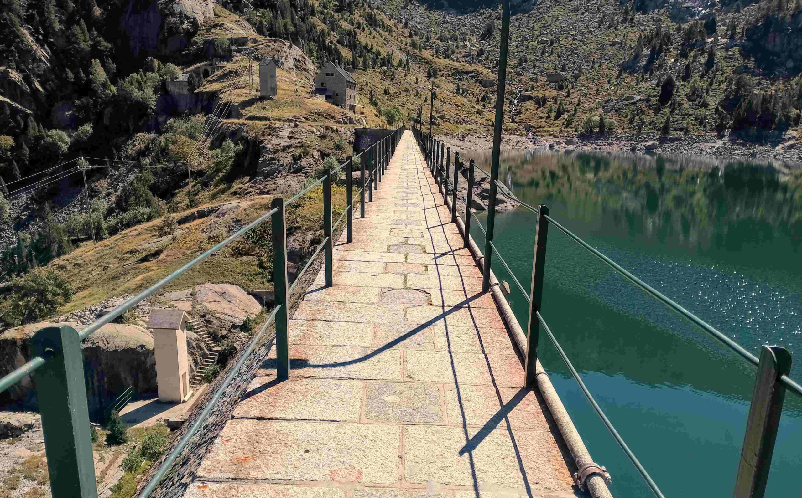
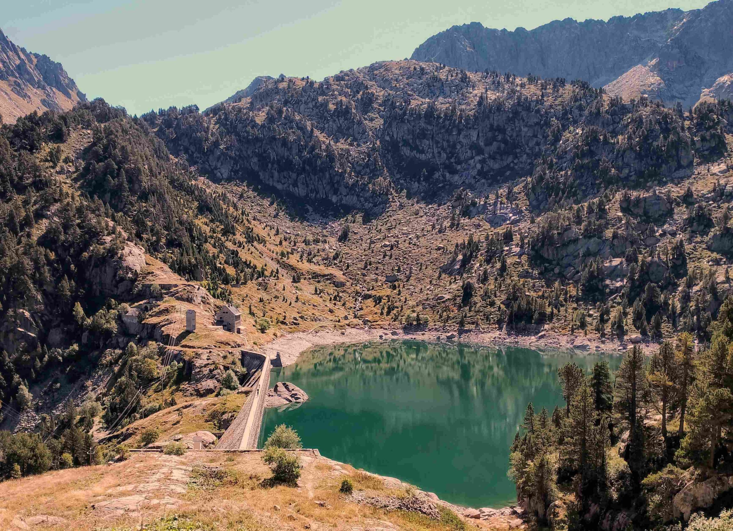
Keep straight on to a sign and turn off left following the arrows for Montardo and the Restanca refuge. Now on a path, the climb proper begins. It’s a wonderful section, particularly in the autumn, ascending through the deciduous trees which produce a kaleidoscope of colour when the leaves are on the change. In places the path is paved, which gives notice that this is a popular route in August and at bank holiday weekends. The climb is fairly steep but not a backbreaker and the path emerges below the dam at the Restanca lake. One last hop up and the walker emerges at a wonderful spot, looking across the lake and the surrounding mountains. Our route bears left to cross the dam to reach the Restanca refuge which stands at 2,010m. This first part of the walk is 4.2km in length with approximately 650m of ascent.
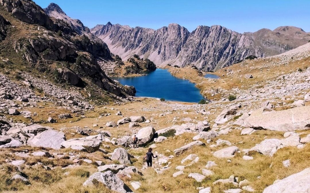
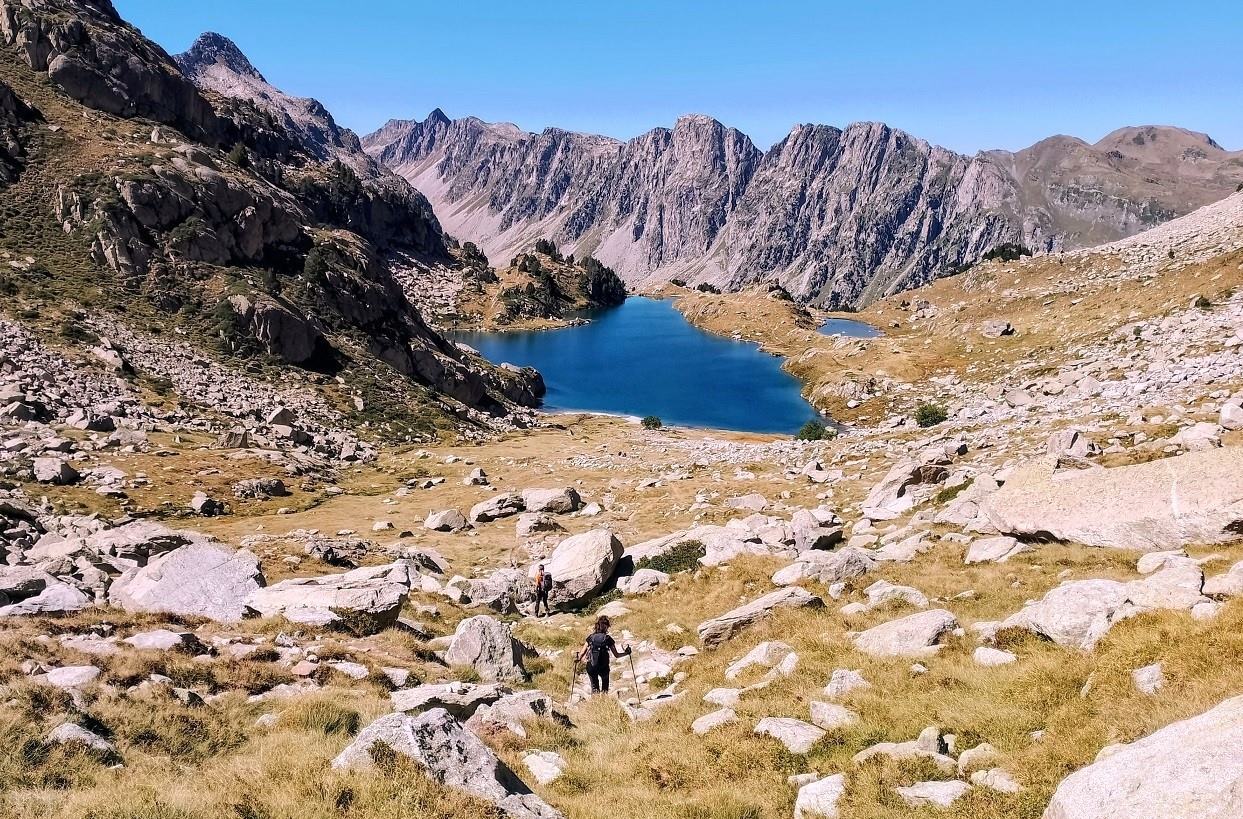
The second leg leads to the Colomers mountain refuge through some extraordinary high mountain areas. The sign at Restanca points out that the walker is now on the GR 11.18 heading for Colomers. Following the red/white waymarks, there is an initial ascent of just over 200m, a pleasant climb to reach the Cap de Port glacial lake. Walk along the left bank of the lake to then start another ascent of just over 200m. Again is a very enjoyable climb up to Port de Rius pass at 2,475m, which is also known as the Coret de Oelhacretsada (something that helps to distinguish it from the another Port de Rius which is less than 15km away to the west!).
The walker has now emerged into an incredible, undulating high mountain area, where glacial lakes abound. Below and away to the right the Monges lake can be seen. Keep straight on from the pass, following the waymarks. It’s a slight descent at first. Walk around 500m to reach a spot where intrepid hikers will turn left to climb to the summit of Montardo (2,833m). It looks to be a fairly straightforward ascent, but it is not on our agenda for this walk.
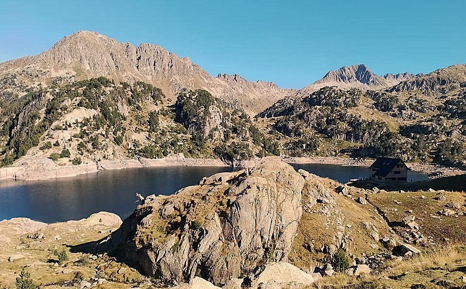
Keep straight on to reach a plateau. There is great view over the area ahead. The path goes down, passing between two glacial lakes – Mangades and Port de Caldes – before embarking on quite a steep but short ascent to the highpoint of the route, the Port de Caldes (or Colomers) pass at 2,567m. As can be expected, the all-encompassing views from the pass are worth enjoying, perhaps while consuming a sandwich. It is quite a long descent to reach the Colomers lake and refuge, which starts off as a rather grassy affair, but boulders come into play before the path starts to follow a lovely stream.
The path emerges at a spot where the lake and refuge can be seen below. Follow the waymarked path down. Be aware that our route branches off to the left before reaching the Colomers lake and refuge – a turn which is very easy to miss. Our turn off is at a rock which bears the waymarks of the GR. It is above the signposts and around 150m in distance from the lake shore. This second section of the walk measures 7km with 640m of ascent and walkers can stay at the refuge if they are intending to break up this long day in the mountains.
The final leg is approximately 10km with around 250 metres of ascent. At the rock the walker is moving off the GR-11.18 and onto the GR-11 – still following red/white waymarks. It’s a short-ish ascent, with the path going up a fairly steep grassy slope replete with the obligatory rocks and boulders. Emerge at a high area above the lake, before going on and then over into the next valley.
The path now embarks on a traverse along the side of the valley, losing a little height at first. In a couple of places there are areas where the path has become eroded so care has to be taken. It feels like quite a long sweep down before arriving at a dogleg to start the short ascent to the Port de Colomers; the second pass in the area with the same name. It’s not a steep climb and the path eventually emerges at 2,323m. There are wonderful views once more from this spot, particularly down over the area still to be covered on the walk and the Montcasau glacial lake. The descent to the lake is not too onerous, then there is a very pleasant path which runs just above the shore on the right-hand side of Montcasau – one lake which appears to be split into two parts.
From the lake there is a short descent which is a little worn in places. Following the stream, the incline of the path becomes less pronounced and it meets up with a track. Once on the track stick to it. After around 1.5 km come to a wider track and turn left to continue the descent. Pass the Pont de Loseron and on to the junction with the road/track close to the parking area. Here turn right and head back to the car.
The full route around the Montardo measures 21km with 1,540 metres of ascent. The day walk will take 10 to 12 hours.
Recent Comments