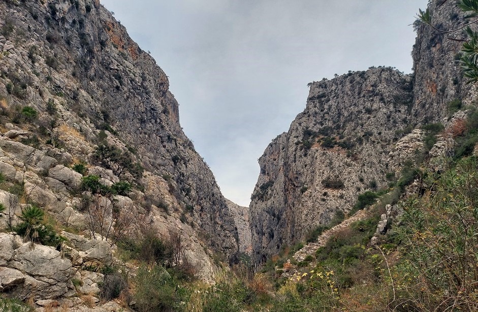
The PR-CV 147 footpath takes in one of Alicante province’s most spectacular geographical features; the Barranco del Infierno (hell’s ravine). On most days of the year the infamous, sheer-sided gulley belies its fearsome name – and walkers admire the towering rock walls in a tranquil silence. But during heavy rain it turns into a ferocious torrent and people have met tragic ends by trying to cross it or descend it when it is in spate.
The flood ravine runs from near the village of Vall de Ebo towards Fleix and the Vall de Laguart. The mountains of the Sierra de la Carrasca on one side and the Sierra del Migdía on the other form the walls of the gorge, which are hundreds of metres high.
While the Barranco del Infierno is undoubtedly the star attraction on the waymarked route, it is certainly not the only one. The area is steeped in history, as the remote valleys served as a refuge for the ‘moriscos’ in the 17th century – Moors who had ostensibly converted to Christianity following the Reconquest, and who were fleeing from persecution. They fashioned an amazing series of trails through the valleys and gorges so they could access the terraced slopes they constructed to grow produce. Although they were built around 500 years ago, the paths still survive today, although sections are crumbling.
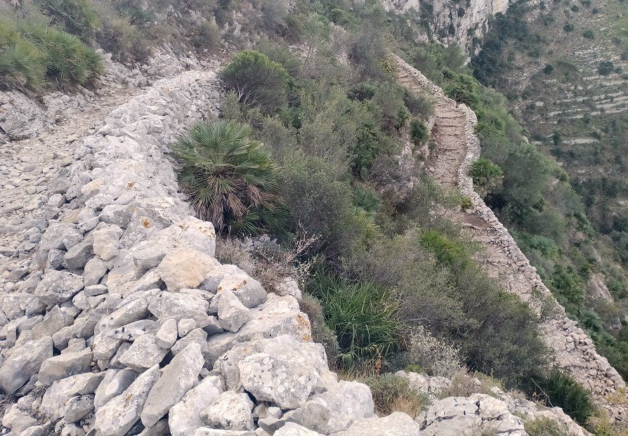
Nowhere was out of bounds for these builders. Their trails dive in and out of the gorges, climb mountain slopes, and traverse ridges. To make the climbing easier, they created switch-back paths with steps. The regional walking federation, the FEMECV, notes that there are ‘more than 10,000 steps, many of them flanked by dry stone walls’ on the PR-CV 147. However, other sources refer to the ‘walk of the 6,000 steps’, with Las Provincias newspaper coming up with the very precise figure of 6,873 steps. I have to admit that I haven’t counted them. Also, erosion has meant that in places the ‘steps’ are no longer well defined.
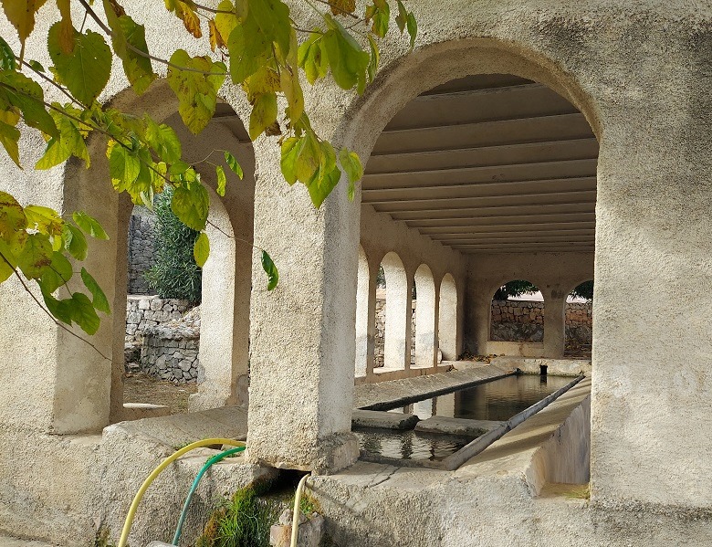
One thing that cannot be contested is that the route offers magnificent moments, which is why it is also known as the ‘Catedral del Senderismo’ (cathedral of hiking). Walkers will also enjoy the natural springs and old washhouses which have been lovingly restored.
It’s a circular route from the village of Fleix and, as such, can be done clockwise or anti-clockwise. Although the ‘official’ route goes anti-clockwise, I found that it is better to go the other way, because it affords much more impressive views over the Barranco del Infierno – ie, rather than having to constantly turn round to see down it, you are looking straight at it on the approach.
The walk is well-signposted and waymarked with while/yellow stripes. It incorporates four ascents and three long descents, traversing some of the most beautiful countryside in the province. One of these is the path down into hell’s ravine and the climb out the other side. Although the PR-CV 147 goes pretty much straight back out of the gulley, it is possible to do some exploring along the bed of the ravine to get a better view of its incredible rock walls.
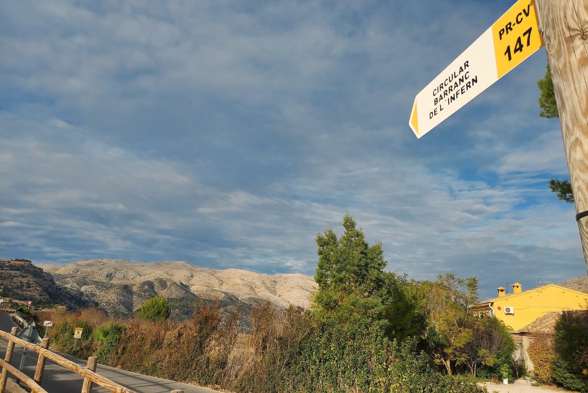
To get to the start point, drive up the Vall de Laguart from Orba and enter Fleix on the CV-721, passing through the village. Heading out towards Benimaurell, you will spot a large parking area on the left (at the back of Fleix), where there is also a sign for the PR-CV 147.
The route
After parking up, head out of the car park, cross the road – as indicated by the sign – and walk for around 100 metres up the main road away from the village, then bear right onto a lane, where there is another sign which tells us that Benimaurell is 2km away.
The lane descends gently to the old public washhouse and an adjacent natural spring, the Font Grossa. Next to the spring there is an information board which gives details of the walk and shows height gain, descent, etc.
Continue along the lane. Soon a sign appears, offering a right turn for the Juvees d’Enmig. The ‘official’ information tells us to do the walk in this anti-clockwise fashion, heading to the ‘Juvees’. However, much better views of hell’s ravine are gleaned from going in a clockwise fashion.
A pleasant country lane leads to Benimaurell – the last village in the Laguart valley. Approaching the village, another restored washhouse appears on the left-hand side of the lane, this one perhaps even more intricate and beautiful than the one in Fleix. It invites admiring glances.
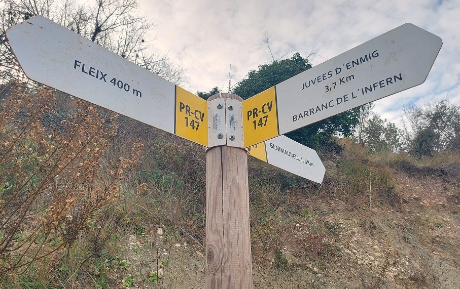
Pass the natural spring, then climb the steps to reach the first of the village streets. The official route bears right to head round the edge of Benimaurell. But it is also possible to walk straight up through the village. Both routes lead to the far side of the village, where just one surfaced road continues in a westerly direction, heading for the Juvees d’Alt, which are 4.1km away, according to the signpost.
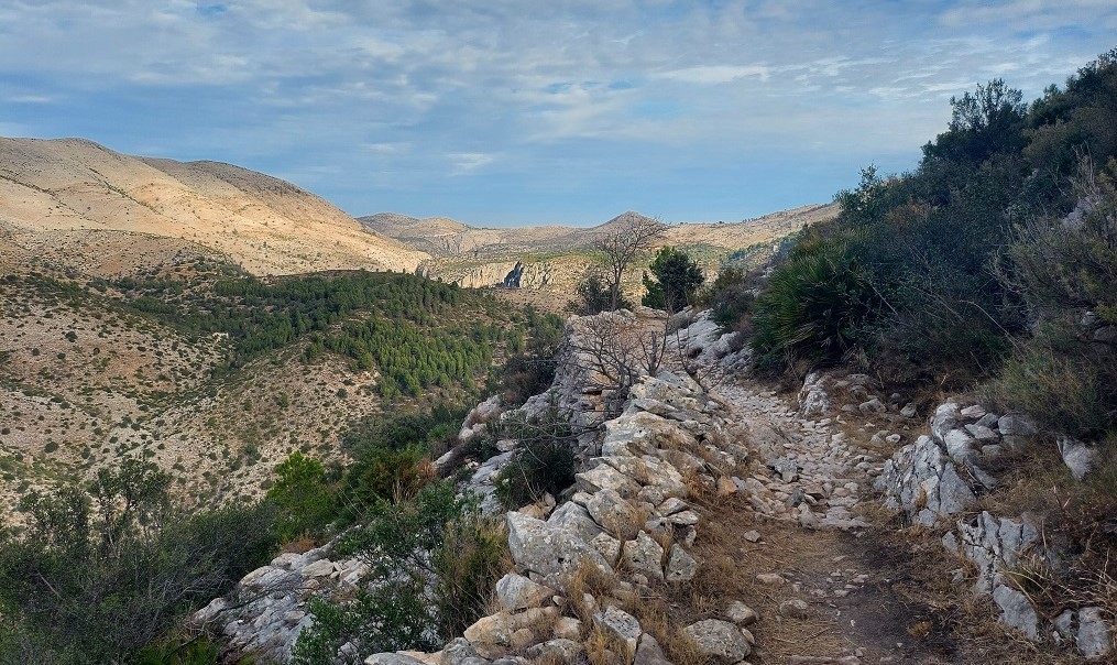
White and yellow waymarks appear on old grey-stone walls which reminded me of Wales. The lane runs past the Font dels Olbits spring and picnic area, then ascends to reach the next signpost which notes that the Juvees d’Alt are now 3.4km away. Here, it’s a right turn off the lane to get onto a path, setting out for the ravines. Follow the path alongside the dry stone wall to the vast terraced hillside, parts of which would have been farmed in yesteryear. Soon the path embarks on the first long, switchback descent. There are fantastic views over the surrounding gulleys and hillsides, with the ravines cutting through the high ground at will, seemingly forming a maze of steep-sided conduits.
Even though the track was constructed around 500 years ago it has held up very well in most places. The ‘steps’ have suffered erosion but it is still a good walking route. As the trail heads down towards the valley/gulley floor, the track turns into a path. At the valley floor bear right to walk down the dry stream bed for around 30 metres before picking up the trail on the left, observing the white/yellow waymarks which help with orientation.
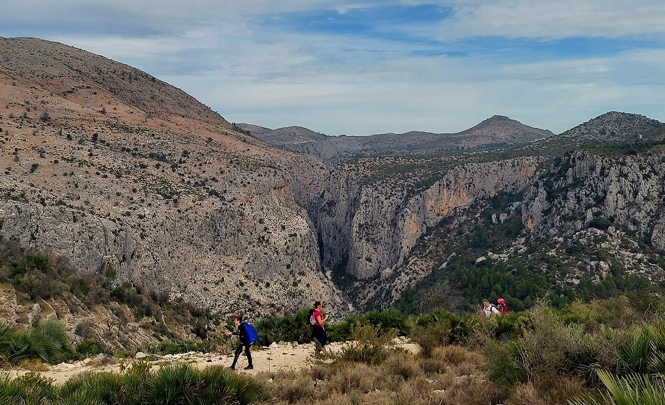
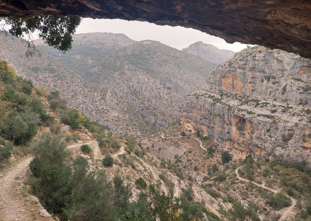
Then start the climb to the Juvees d’Alt. The path goes up and then flattens out to head along the side of a shallow ravine. Then an old abandoned farmstead appears on the left. Further on, the path passes through dwarf fan palms, before reaching a wide track where a sign tells us that the Juvees d’Enmig are 3.2km away (even though we haven’t yet reached the Juvees d’Alt). Bear right to follow the track, passing more abandoned farmsteads. As the track rises we have our first view of the awesome Barranco del Infierno. Walking along the high track, it affords panoramic vistas across to hell’s ravine.
The track leads to the Juvees d’Alt, where there is another old farmhouse and a well. Here the signpost has been partially vandalised. We take a left turn, following the sign that points for the path which will take us down and into hell’s ravine. With the advantage of height and perspective, the views of the ravine are best from this top section. A series of incredible vistas unfold as the path describes its switchback descent and the full scale of the sheer walls of the gorge becomes apparent. It’s not a descent to be hurried.
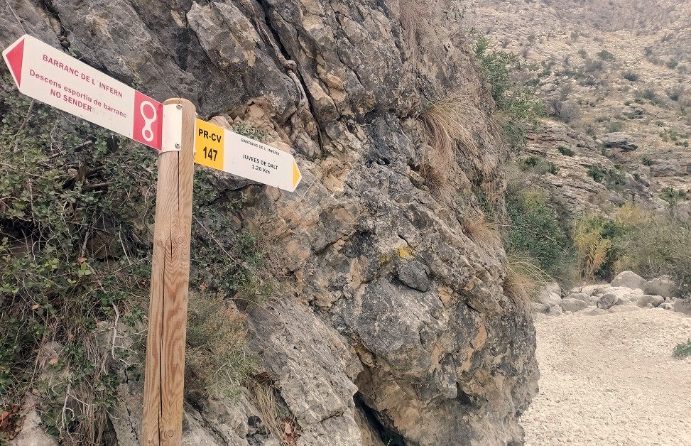
At the bottom the path emerges into the bed of the ravine. Although often dry, it is possible to see evidence of very fast-flowing water – the sculpted boulders and large ‘pebbles’ which are moved by the torrent during intense downpours. The PR-CV 147 route only spends a very short time in the ravine – the footpath bears right and heads down the boulder-strewn dry river bed before turning left to take up the trail on the other side. It is less than 100 metres to the turn off – and there is a signpost opposite it, which can be used as a marker. The footpath heading out of the ravine is fairly concealed and people have got lost in the past by missing it.
Experienced walkers may want to explore more of the ravine – something that should only be done when they have plenty of time to complete the waymarked route and not after heavy rain. By turning left at the entry point to the ‘barranco’ instead of right they will be able to walk up the bed of the ravine to the sheer-sided rock walls where the gulley narrows down, circumventing enormous boulders en route. After around 10 minutes, progress becomes more difficult as the rock walls close in and this is where walkers will think about turning back.
Back on track, at the exit point from hell’s ravine, walkers will notice the red section on the sign opposite. This points down the ravine and states that it is not a footpath, rather a ‘sporting descent’ for canyoners. Experienced walkers may be tempted to walk down the bed of the ravine as far as the point where the canyon narrows, and then turn back.
Climbing out of hell’s ravine on the PR-CV 147, it is 500 metres in distance up to the natural spring – the Font del Reinos. Initially, coming out of the ravine, there are good views back down. Then the vegetation closes in, although there are fleeting glimpses of the rock walls of the ravine near the natural spring.
From the ‘font’, it is 1.1km to the next signposted area, the Juvees d’Enmig. As the path climbs, it emerges from the dense vegetation and passes close to and under an enormous slab of rock, which forms part of the highest section of the ravine walls. Its different colours – a sandy brown and grey/granite, show a mix of rock formations. The views back across to the area traversed earlier in the walk are stunning.
The path flattens out and runs through land which was cultivated (only some of it still tended) before emerging at the Juvees d’Enmig. One of the main features here is an enormous leafy tree, which on closer examination is actually several trees, providing ample shade. There are also farmhouses, some of them abandoned, some renovated. Turn right onto the wide track and walk up to the surfaced lane, where there are signs and information boards giving details of the PR-CV 147. The signs tell us that it is 4.1km to get back to Fleix.
Turn right to walk along the lane, following the white/yellow waymarks. It is around 400m to the next signpost, where the lane ends and a path starts. Another signpost explains that this spot is the Pou de les Juvees (with ‘pou’ being a well in Valencian). Fleix is 3.7km away, and its 1.9km to get to the River Girona, which is the waterway that runs through hell’s ravine.
It is a pleasant walk, first through vegetation and a wood, then back out into the open, where the ancient trail runs high and proud with dramatic views back across to the mountainous area around Fleix and beyond.
The track emerges above hell’s ravine once more, although here it is much wider and a little less monumental. The switchback, stepped track starts the descent back into the ravine, with a view across to the ascending track on the opposite side, which is the final long climb back to Fleix.
Reaching the valley floor, cross the dry river bed, with good views of a different part of the ‘Barranco del Infierno’. On the far side notice the wooden post with a white/yellow waymark which indicates the start of the long, final ascent. It’s a clear path, which was again constructed by the ‘ancients’ and contains steps in some parts. There are dramatic rock formations to gaze on as the track/path rises, again using switch-back to progressively gain height.
After rainfall a spectacular waterfall soon becomes visible. But after a prolonged dry spell there is no water to fall. The route continues up, passing through a hole in the rock – a very short tunnel which is a peculiar feature with a cave next to it. By rights, you feel that this should mark the end of the climb. It doesn’t. There is still some way to go before the path emerges close to the washhouse in Fleix. You will probably want a sit down here before cajoling your tired legs back into action to retrace your steps to the car park.
For the walk ‘facts’, we have a dilemma. Different measurements appear on walk boards at different parts of the route. The newest board tells us that this round walk is 13.1km, while an older one has it down as 14.5km – take your pick. We are also told that there is 808m of ascent. They say five hours, but I would suggest that it will take between five and six hours, depending on fitness, rests and extra exploring.
You need to have experience of mountain walking and a good level of fitness to be able to take on this route. It can be done at any time of the year, but a summer excursion would require a pre-dawn start (very first light) and a finish before noon as it can get extremely hot in hell’s ravine.
A word of warning – DO NOT attempt the Barranco del Infierno walk during or straight after heavy rain. Wait until the weather is set fair.

Recent Comments