The Sierra de Callosa is the jagged lump of rock that rises out of the south-western corner of the Vega Baja plain in the deep south of Alicante province. In the area, it is rivalled only by nearby Sierra de Orihuela, which is slightly higher and slightly longer in its extension.
The high, eroded rock faces mean that it is very popular with climbers, who are in their element on the varied pitches. Due to the terrain, it means that some climbing moves are required on the steep slopes when walking to the main summit.
This route is one of the several different ascents on the Sierra de Callosa. It’s a circular walk which follows waymarked trails. However, a note of caution should be sounded. Parts of this ascent are extreme. There are very steep climbs up ravines and a section across an eroded slope that is very much heart-in-the-mouth stuff and which, in my opinion, verges on the dangerous, as a slip would result in a fatal fall. Therefore it is a route that should only be attempted by very experienced mountain walkers and people who have a good head for heights. It is certainly not for the faint-hearted.
You may well ask why it’s included here, with the misgivings that I’ve expressed. The main reason is that the extreme part of the ascent is on a route highlighted by the regional walking federation, the FEMECV. It is signposted off a much less challenging footpath and could be taken in error as there is no indication that it is a seriously difficult climb for inexperienced walkers. The route, on the SL-CV 146, is promoted by Redován town hall and appears on the FEMECV website with an interactive map.
But, if you have any misgivings about this route after reading the description and seeing the photos, then do not attempt to do it. Some people enjoy extremely challenging ascents. This one will certainly not be to everyone’s liking; but it is there, and it is waymarked, and some walkers may want to take it on. However, they should consider the risks before setting out and be aware of what they are letting themselves in for.
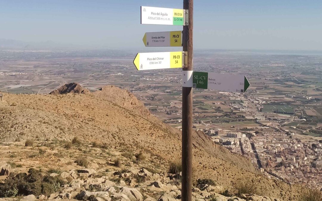
The main summit on the Sierra de Callosa is another Pico del Águila (eagle’s peak), with one of the same name situated in the adjacent Sierra de Orihuela. This mountain is slightly lower, reaching a height of 568 metres. As well as the expansive views over the Vega Baja, the sierra is home to birds such as Bonelli’s eagle and the Eurasian eagle owl. The first section on the less steep PR-CV 54.3 is also a pilgrim route to a Virgin’s cave. It joins the SL-CV 146 route soon afterwards. The PR route has white/yellow waymarks and the SL has white/green waymarks.
The walk starts at Cueva Ahumada recreation area just to the south of Callosa de Segura town centre and there is ample space to park. Also, it gets very hot in this area from June to October and this route should not be attempted in very warm weather.
The route
Park up close to the walk signs in the Cueva Ahumada recreation area. The posts point for the mountain straight ahead, on the PR-CV 54.3 and also PR-CV 441 heading for the Mirador de la Vega vantage point. The path heads up steps and along the left-hand side of a wide ravine, where extensive flood prevention infrastructure has been constructed in recent years following the 2019 flooding disaster.
Do not turn off for the Cueva Ahumada (unless you want to!), keep straight on the wide track which leads up towards the vía ferrata and climbing zone. At the next sign our route bears left to head for the Mirador, while the climbers turn right. The waymarked path passes to the right of the cemetery wall and bears right to ascend a steep, stepped path with a handrail. It emerges at the vantage point, where there are views over the Vega Baja and to the Sierra de Orihuela.
Next up, the path is heading for the Cruz del Relojero viewing point, which is 0.7km distant. The route heads across the slope, then starts to ascend from the next sign. Soon the path arrives at the Virgen de la Cueva, a cave with a small shrine and statue inside. Continue on, around the hillside. The path climbs to a saddle and drops down through an area of pine trees to reach the Cruz del Relojero vantage point, where there is a cross (cruz). From here, bear right to descend for 0.5km to the turn off for the SL-CV 146, where the sign states that it is 1.7km to the summit of the Pico del Águila.
The path starts off following a ravine, with the white/green waymarks showing the way. It then bears right to climb out of the ravine and head around the side of the mountain, moving back in the direction already travelled but at a higher altitude. The path swings round to the left to start climbing again. At this point pay great attention to the waymarks; the path does not ascend the ravine but bears to the right to ascend on an outer line and head up the side of the mountain to a marker post.
Further marker posts and waymarks help show the way up the mountain slope, emerging at a pitted rock face with caves. Climb up to the right of the caves. There is a fixed wire to help with the ascent to another post. This is where the path bears left to traverse across the slope; it’s the very dodgy section. Enormous care has to be taken here. There are drops off the slope on the left and a fall would almost certainly prove fatal. Full concentration is needed. Tread very carefully on the narrow path.
A series of three marker posts show the way up the next part of the slope. It is a steep climb and there is some rock to negotiate. Finally the path moves away to the right, where there are signposts. It is a tremendous relief to get off this section. At the sign, bear right; the information tells us that there is 422 metres in distance to cover to get to the summit.
The path turns the corner and heads across to another post. The path is now in a ravine. Down below see one of the footbridges of the via ferrata. Our path bears right to head up the rocky slope of the ravine. The path favours the left, heading up to another marker post, where the path moves to the right to continue the very steep ascent.
Emerge at a saddle at the top of the ravine, where there is a marker post. The path bears left to start the final short ascent to the summit. From the saddle, the route moves across to the right and up a rocky ridge. There is a fixed wire near the start to help out. In a fitting end to the climb, there is a scramble up a rockface with precipitous drops off to the left to reach the summit area.
Up top you will probably feel immense relief that you have arrived in one piece. It’s a wide area, but be aware that fatal drops await near the section where you have emerged. It worth taking time to enjoy the views after the effort and nervous energy expended.
The signs show that the descent is on the PR-CV 54 and it is 1.76km to get to the Ermita del Pilar (Pilar hermitage). It’s a right turn from the point you emerged at. Set off down the wide ridge, heading for the stone hut and passing just to the right of it. Follow the white/yellow waymarks, heading over the top of the rise and down a ridge. Then the route turns right to start the descent of a very steep ravine. Follow the waymarks as they plot a course down.
Soon the path bears right, to move across the slope, ascending slightly on some parts of the traverse. The path moves onto a wide ridge, high above the cemetery which is down below on the right.
It is very important to pay complete attention to the waymarks. If you haven’t seen one for a while, retrace your steps because you have gone wrong. Going down the mountain, the path swings round to the right and charts its way around the rocky slope. It’s a long and slow descent. The path alternates between steep sections of descent and areas where it moves across the slope. Follow the waymarks.
Finally, things become easier towards the bottom and the path emerges at the hermitage area (La Pilarica). Here, follow the signs that point right, across the footbridge, now on the route heading for the Santuario de San Roque church on the SL-CV 175 and following white/green waymarks. It tells us that it is 0.99km to reach the place of worship. The path heads down the right-hand side of the flood ravine. Reach the fence and go down the side of it to the wide concrete walkway which heads towards the church in the distance. After around 40 metres on the concrete path the route bears right to ascend for 10 metres, before flattening out and then crossing the slope.
The path traverses round the slope, eventually swinging to the right just before the church. Head round the bottom of the rocky section to pass to the right of the church wall and emerge at the vantage point in front of the church. Here notice the next church on the skyline; this is the direction we want. Walk down the other side of the Santuario de San Roque and bear right. Then take the second right, heading down Calle Jaime 1 el Conquistador. Go as far as the local police station, bearing right just before it to walk down Calle Mayor, then on to Calle Salitre. Follow Calle Salitre to the roundabout on the CV-900 road and walk on the pavement along the CV-900 to reach the Cueva Ahumada recreation area which is on the right, just after passing under the AVE railway bridge.
Walk Facts
Length – 8.5km; time – four to five hours; ascent – approx 650 metres; difficulty – extreme; season – spring, autumn, winter; getting to the walk – take the CV-900 road from Callosa de Segura towards Redován. Turn off for the Cueva Ahumada recreation area after around 0.5 kilometres, just after passing under the railway bridge


Recent Comments